Introduction to the Game of Thrones Map
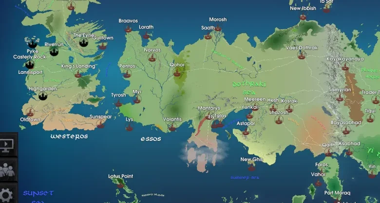
The Game of Thrones map serves as a crucial tool for fans and scholars alike, providing an intricate visual representation of the fictional worlds of Westeros and Essos. Crafted by George R.R. Martin, this expansive land is filled with detailed locations that reflect the political, cultural, and geographical complexities found throughout the series. Understanding the layout of this map is indispensable for comprehending the narrative’s depth and character interactions.
This map highlights various kingdoms, cities, and significant landmarks, allowing viewers to grasp the vast distances that characters traverse in their quests for power and survival. From the icy lands of the North to the sun-soaked shores of Dorne, the Game of Thrones map reveals not only the physical terrain but also the shifting allegiances and hostilities that are characteristic of the story. Each location, whether it be King’s Landing or Braavos, plays a pivotal role in the overarching narrative, making the map an essential reference point.
Moreover, the geographical features such as the Narrow Sea, the Wall, and the Haunted Forest add layers of complexity to the political dynamics within the series. The map delineates the regions controlled by various houses, each represented by their sigils and colors, which aids viewers in tracking the ongoing power struggles and dynamic relationships between key players. It also provides context for the alliances and rivalries that shape the destiny of Westeros and Essos. By studying the Game of Thrones map, fans can enhance their understanding of the storytelling, ultimately deepening their engagement with the rich lore that Martin has created.
The Geography of Westeros
The Game of Thrones map is a rich tapestry of diverse regions, each with its own distinct characteristics and histories. At the northernmost point lies the North, a vast expanse characterized by its cold climate and rugged terrain. The Stark family, the principal house of this region, rules from Winterfell, a formidable castle that serves as a symbol of Northern resilience. This area is known for its strong traditions and loyalty, with unique features such as the Wall, an immense fortification that keeps the realm safe from dangers beyond.
Progressing southward, the fertile region of the Riverlands emerges. This area, centrally located on the Game of Thrones map, is known for its rivers and forests, playing host to numerous noble houses, including the Tullys of Riverrun. The Riverlands are a crucial crossroads for military and trade routes, often becoming the battleground for conflicts due to their strategic importance.
Further south, one encounters the Vale of Arryn, a mountainous region known for its impregnable castles, such as the Eyrie, perched high above cliffs. The Arryn family, known for their chivalry, governs the Vale. Beyond this lies the Westerlands, home to House Lannister, whose stronghold of Casterly Rock stands as a testament to their wealth and power.
To the south, Dorne distinguishes itself with its warm climate and unique customs. Governed by House Martell from Sunspear, Dorne features a terrain that varies from dry deserts to lush gardens. This region is renowned for its distinct cultural practices, setting it apart from the other areas of Westeros.
Throughout these regions, the Game of Thrones map reveals a complex interplay of geography and politics, where each house’s influence shapes the broader canvas of the realm. Understanding the diverse landscapes of Westeros not only adds depth to the storyline but also highlights the intricate relationships that define the Seven Kingdoms.
The Land of Essos
Essos, the expansive continent located directly east of Westeros, serves as a crucial backdrop in the narrative of “Game of Thrones.” Renowned for its diverse cultures, landscapes, and political intrigues, this region is marked by a rich history that significantly influences the storyline. Major cities such as Braavos, Volantis, and Meereen are notable landmarks on the “Game of Thrones” map, each contributing uniquely to the series’ fabric.
Braavos, one of the Free Cities, is famed for its canals and the iconic Iron Bank, which plays a pivotal role in financing the various factions throughout the series. Its independence from the ruling families of Westeros underscores the stark contrast between the two continents. The cultural nuances of Braavos, characterized by a unique blend of commerce, wealth, and distinct social structures, illustrate the diverse world that exists beyond the Seven Kingdoms.
Volantis, another significant city, is the oldest and largest of the Free Cities. Known for its opulent architecture and the presence of the wealthy elite, Volantis highlights the vibrant trade routes that traverse Essos. The comparison with Westeros becomes evident with Volantis’ focus on commerce and politics, which often differ substantially from the feudal systems dominant in Westeros. It is here that the cultural clash becomes palpable, revealing how the intricate dynamics of power operate distinctly across the sea.
Lastly, Meereen stands out as a pivotal location in the narrative, especially during Daenerys Targaryen’s journey. This ancient city, with its fighting pits and colossal pyramids, represents the complexities of slavery, liberation, and leadership. As with the other regions of Essos, Meereen’s societal structure further diverges from those in Westeros, showcasing the varied ways in which people govern and coexist. Through these key cities, the “Game of Thrones” map effectively encapsulates the cultural richness and geopolitical complexities that define the land of Essos.
Key Locations in the Series
The Game of Thrones map serves as an intricate representation of the various locations that play pivotal roles throughout the series. At the center of many events is King’s Landing, the capital of the Seven Kingdoms. It is a bustling metropolis, home to the Iron Throne and several noble houses vying for power. King’s Landing is not only politically significant but also culturally rich, with landmarks such as the Red Keep and the Great Sept of Baelor, each providing essential context for the unfolding storylines.
Another prominent location depicted on the Game of Thrones map is Winterfell, the ancestral seat of House Stark. This sprawling castle, surrounded by vast forests and fields, symbolizes the Stark family’s values of honor and loyalty. Winterfell’s significance extends beyond its physical structure; it serves as a home to numerous characters, helping develop intricate relationships and subplot narratives throughout the series. The castle also acts as a crucial location in the battle for the North, which is highlighted throughout the seasons.
Additionally, the Wall embodies one of the most critical locations within the Game of Thrones universe. Stretching for miles to the north, the Wall acts as a barrier between the Seven Kingdoms and the dangers that lurk beyond. The Night’s Watch, an organization dedicated to guarding the realm, is stationed there, emphasizing themes of duty and sacrifice. The Wall is not only a geographical feature but a representation of the tensions between the Seven Kingdoms and the unknown threats from the far North, which dramatically shape the narratives as the series progresses.
By examining these key locations and their significance, we can better appreciate the complexities of the Game of Thrones map and how it reflects the rich tapestry of conflicts, alliances, and character developments present in the series.
The Importance of the Map in Plot Development
The Game of Thrones map plays a pivotal role in the evolution of the plot throughout the series. It serves not only as a physical representation of the fictional land of Westeros and Essos but also as a strategic blueprint that significantly influences character decisions, movements, and the overall narrative. The geographic diversity depicted on the map is essential in understanding the challenges and advantages faced by various factions, which ultimately shapes the trajectory of the storyline.
Geography is intricately tied to the characters’ journeys, dictating their options and opportunities. For instance, when Daenerys Targaryen embarks on her quest to reclaim the Iron Throne, the Game of Thrones map illustrates her path across the continent, showcasing key locations like Meereen and Westeros, which are central to her character development and the conflicts she faces. As an aspiring queen, her movements are crucially constrained and influenced by the geographical barriers and strategic alliances depicted in the map.
Moreover, the map highlights the significant feature of various factions’ territories, such as the Lannisters in the West and the Starks in the North. This geographical segmentation adds layers of conflict as tensions escalate between the houses, effectively employing the map as a storytelling device. Key battles occur at pivotal locations, such as the Battle of the Blackwater or the battle at Winterfell, significant events that are grounded in the reality of the Game of Thrones map.
Additionally, the map serves as an informative tool for audiences, allowing viewers to visualize the length and complexity of quests undertaken by characters. This understanding enhances the stakes of the narrative and fosters a deeper connection with the intricate plots that are constantly intertwining across vast distances. Ultimately, the geographical context provided by the Game of Thrones map enriches the story, making it a vital component in the series’ plot development.
Iconic Battles and Events on the Game of Thrones Map
The world depicted in “Game of Thrones,” a fantasy series based on George R.R. Martin’s “A Song of Ice and Fire,” is marked by a number of significant battles and events that unfold across its expansive map. Among these, the Battle of the Blackwater stands out as a pivotal moment in the series. Taking place in King’s Landing, this battle showcased the fierce conflict between Stannis Baratheon’s forces and the loyalists of King Joffrey Baratheon. The clever use of wildfire by Tyrion Lannister not only altered the tide of the battle but also highlighted strategic ingenuity against overwhelming odds, leaving an indelible mark on the history of Westeros.
Another notable event is the Siege of Winterfell, which serves as a crucial point on the Game of Thrones map. During the storyline, Theon Greyjoy seizes Winterfell, capturing it in a plot that ultimately fails. This siege illustrates the complex web of alliances and betrayals that characterizes the series. The location of Winterfell not only signifies the heart of the North but also symbolizes the Stark family’s enduring legacy and struggles throughout the series. The battles fought here underline the relentless pursuit of power and the tragic fates that accompany such ambitions.
The Red Wedding is yet another significant event that takes place within the context of the Game of Thrones map. Occurring at the Twins, this event marks a dark twist in the narrative, as it sees the Stark family suffer devastating losses due to betrayal. The Red Wedding exemplifies how geography plays a crucial role in the narrative’s unfolding, with specific locations becoming synonymous with epic events. Each battle and event on the Game of Thrones map not only drives the plot forward but also enhances the viewer’s understanding of the multifaceted relationships and conflicts between the characters, making it an integral part of the show’s allure.
Fan Interactions and Map Exploration
The richly detailed game of thrones map has captivated fans since the series first aired. Audiences have not only engaged with the official maps provided in the various media but have also taken it upon themselves to create fan-made maps that capture their interpretations of Westeros and Essos. These fan-created versions often include imaginative elements and nuanced interpretations of geographical features, which can enhance the storytelling of the series. Many talented artists and cartographers have contributed their skills to producing an array of maps that depict lesser-known locations or alternative interpretations of familiar places.
Online forums and social media platforms serve as popular venues for fans to discuss and analyze the game of thrones map in detail. These discussions frequently delve into the significance of certain locations, the strategic importance of particular routes, and the implications of the geography on the unfolding narratives. Such conversations often reveal deeper insights and theories as fans analyze distances, travel times, and political affiliations among the regions depicted on the map. The collaborative nature of these discussions allows for a rich exchange of ideas, leading to compelling fan theories that further enrich the lore of the series.
Moreover, geography plays a crucial role in how fans interpret character motivations and plot developments. For instance, the proximity of certain territories can influence alliances, conflicts, and even character decisions, which fans are eager to dissect and debate. Many fan theories stem from thorough examinations of the game of thrones map, showcasing a blend of creativity and analytical thinking. In light of these interactions, it is clear that fans derive immense joy from exploring the game’s geography; the map becomes not just a tool for navigation but a canvas for storytelling and speculation.
The Evolution of the Game of Thrones Map
The Game of Thrones map has undergone significant transformations from its inception in George R.R. Martin’s “A Song of Ice and Fire” series to its popular HBO adaptation. Initially, the map served as a functional tool to provide readers a geographical context for the complex narrative woven throughout the novels. The intricate details and characters’ journeys were laid out across the Seven Kingdoms, including key locations such as King’s Landing, Winterfell, and the Wall, allowing fans to visualize the sprawling world that Martin created.
As the HBO series debuted, the need for a more dynamic representation of the Game of Thrones map arose. The production team aimed to enhance viewer engagement by presenting the landscapes and locations with visual depth. This led to a more three-dimensional approach to the map, introducing computer-generated imagery (CGI) that vividly illustrated various regions, their political significance, and their dramatic topography. Locations were not just marked but brought to life, with shifting seasons and atmospheric changes reflecting the evolving narrative, enhancing the overall storytelling experience.
Comparatively, the geographical representation evolved to accommodate narrative shifts highlighted in the television adaptation. Certain regions, previously shown in detail in the books, were sometimes merged or altered for pacing and visual storytelling. For example, while the novels provided exhaustive explorations of Dorne and its cultural significance, the television rendition opted for a streamlined depiction, focusing on pivotal plot points. This evolution reflects not only the practical demands of television production but also the creators’ interpretations of the source material, which has generated discussions among fans regarding fidelity to the original Game of Thrones map.
In conclusion, the evolution of the Game of Thrones map mirrors the transition from page to screen, highlighting the intricate balance between fidelity to the original text and the creative liberties taken to enhance viewer engagement. Understanding these changes allows fans to appreciate the landscape of Westeros and its impact on the jubilation and tragedy of the characters that inhabit it.
Conclusion: The Enduring Legacy of the Game of Thrones Map
The Game of Thrones map serves not only as a geographical representation of the Seven Kingdoms but also as a pivotal element in the storytelling and world-building that defines the series. Its intricacies and detailed terrain allow viewers and readers to become more immersed in the epic saga, fostering a deeper connection with the characters and their journeys. Understanding the geography depicted in the Game of Thrones map enhances the overall experience of the series, allowing fans to appreciate the strategic complexities of the various plots unfolding in different locations.
The significance of the Game of Thrones map extends beyond mere navigation of Westeros; it symbolizes the profound impact that geography has on storytelling. The various regions, such as the icy expanse of the North and the scorching deserts of Dorne, influence the cultural, political, and social dynamics of the characters inhabiting them. As audiences traverse the diverse landscapes illustrated on the map, they gain insights into the motivations and behaviors that are often shaped by environmental factors. Thus, the map becomes a living entity in its own right, contributing a rich layer of context to the narrative.
Moreover, the enduring legacy of the Game of Thrones map can be seen in its influence on popular culture. It has inspired fan art, discussions, and fan-generated content, fueling a community eager to explore the lore of the series. As new adaptations and explorations of the Game of Thrones universe emerge, the map remains a crucial point of reference, guiding old and new fans alike through the complexities of the story. In this way, the Game of Thrones map will continue to shape perceptions of the narrative, reminding us that geography is not merely a backdrop but an integral part of the epic tale that captivates audiences worldwide.
You May Also Read This Usaworldtoday.